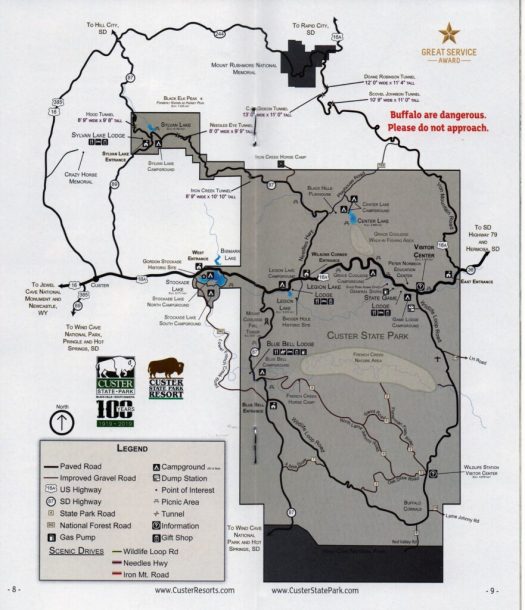
We stayed in the Sylvan Lake area, (note map below)
This camp area has a narrow one-way drive with limited maneuvering room.
It has a fairly new and clean restroom building, However hot water was variable. We spoke to the camp host and they indicated repairs are due the day we left!
There is a nice walking trail to Sylvan lake and the general store. The trail is off the road and safe.
Easy mountain drives to Mt Rushmore and Crazy Horse memorials.
One dump station in entire state park by the Visitor Center!
The Wildlife loop had nice scenery.
Park Maps (Custer State Park and Wind Cave National Park)
What we liked / disliked
Notes
ONE dump station in the entire park!
Water not on site, only community spigots.
The parking pads are not level. Or only small portion of our assigned pad was level for the trailer.
No trash receptacle at dump station.
As mentioned, big rigs will have a problem in the narrow one-way drive in this camp ground.
The General Store is limited in product selection and pricey… more like what you would expect in a tourist destination than a State Park.
Wildlife
Yes! Marmot, Bison, Big Horn Sheep, Mountain Goat, Deer…
Clean shower and restrooms centered in the camping area.
Plenty of room for tent or screen room use at every site.
Nice fire pits, (even a little wood dumped at our site.
Many partially shaded sites, but you would need to drive the area to choose an available site first.
Reservations required for multiple nights on the Nebraska State Parks web site.
Walking paths to the lakes, windmill and gazebo Handicap accessible.
Park Map
What we liked / disliked
Notes
No water at individual sites, only community spigots.
Not easily accessed during construction through the end of 2019!! Eastbound I-80 access forces you to go 5 miles further east and return on the westbound side. This was NOT noted on the state parks website.
We were in the Ray Roberts Lake State Park – Isle du Bois area which had some partial flooding and a few closed camp sites. One of the other campground areas was also closed due to flooding.
Because the staff had not been out to the sites, there were unaware of mud filled sites… and unfortunately we were assigned one of these sites! A trip back to the office solved the problem with a move to another available slot.
We did not see a single park patrol… and it showed from the above point.
The parking pads are not too level so be prepared to spend some quality time with your blocks! 🙂
Park Map
What we liked / disliked
Notes:
The Showers are adequate but in need of an update.
There are walking trails to / from a playground and it appears to be a family friendly area.
This a a very quiet park and very peaceful in the evenings.
Our Site
Dry… but we moved!
Wildlife
We had deer everywhere and geese… watch where you step!
This is a small camping/RV area tucked in the Lost Maples valley with only 30 spaces for tent and RV camping. Our advise, Reserve Early!
The camping area is fairly open without a lot of mature trees.
The restrooms and showers are clean and well kept.
This is a quiet park, with most spaces full, the noise was minimal.
The park staff were very friendly, helpful and showed a great deal of care for managing this little oasis in the woods.
There is a single Dump Station near the entrance on the main road. Dumpsters and recycling bins were plentiful and the guests were keeping the area clean.
What we liked / disliked
This is supposed to be a beautiful park in the Fall with the changing colors of the maple trees. We’ll plan to return to see the colors.
The trails are dog friendly, (leash required), and seemed to be well marked and maintained.
Our stay was short, but the birds were at a minimum and no sign of any four legged critters. We did hear two owls talking to each other… but that was it.
The camping area is disconnected from day-use area by ½ mile park road which was nice to see.
The day use area is large and there are several hiking trails up into the hills – see map below. The trails follow the Sabinal River and branch off into the hills.
The river area is pretty, even for early Spring, even though Spring… had not quite sprung – the colors were flat and the trees had not started to bud out just yet, but as mentioned, we’ll be back in the Fall!
Please support the Texas State Parks and donate here!
Level hard-pack (chip seal) pads for RV and trailers.
Most spaces are back-in and many have ‘T’ or ‘Y’ areas for parking your tow or towed vehicle.
Recycling bins for aluminum cans were near most dumpsters.
A nice picnic area and large overflow parking lot with sidewalks to the beach.
There are two separate dump stations on the roads to the camp areas and not located in the camping areas.
Two restroom buildings with showers, (maybe four when the island camp areas are reopened).
A fish cleaning station is available and the local pelicans will help!
Park Map – note: the Island camp sites are closed at this time.
What we liked / disliked
The park was very clean, quiet and walkable.
There is a nice birding area near one of the shower buildings for attracting and encouraging birds to become accustomed to the human activity.
We noted there were several park hosts and a separate birding host with planned bird walks and talks.
The staff were very helpful and upon check-in, allowed you to drive through the area to pick your space from the available pads
The Big Tree live oak is separate from the park, (about 2 miles walk/ride on a public road). There is a loop road that takes you along the bay for a way to stay off the main roads if you are walking or biking. (GoogleMaps can be your friend)
Media – Local TV stations from Corpus Christi and Victoria are available.
Photos
Trees ripped apart by Harvey
Typical parking row
Typical pad
Nice bird area by showers
Birding area with water/marsh access
Wildlife
Locals at the dock
Things get crowded when someone approaches the fish cleaning station
Only one ‘focused’ on the prize!
The Big Tree
This is one massive tree!
History
Texas State Champion Virginia Live Oak
Island Camp Areas Closed due to Hurricane Harvey
Island camp sites… closed
Unfortunate
This website uses cookies to improve your experience. We'll assume you're ok with this, but you can opt-out if you wish.AcceptRead More
Privacy & Cookies Policy
Privacy Overview
This website uses cookies to improve your experience while you navigate through the website. Out of these, the cookies that are categorized as necessary are stored on your browser as they are essential for the working of basic functionalities of the website. We also use third-party cookies that help us analyze and understand how you use this website. These cookies will be stored in your browser only with your consent. You also have the option to opt-out of these cookies. But opting out of some of these cookies may affect your browsing experience.
Necessary cookies are absolutely essential for the website to function properly. This category only includes cookies that ensures basic functionalities and security features of the website. These cookies do not store any personal information.
Any cookies that may not be particularly necessary for the website to function and is used specifically to collect user personal data via analytics, ads, other embedded contents are termed as non-necessary cookies. It is mandatory to procure user consent prior to running these cookies on your website.